Daily Corn and Soybean Basis Maps for Iowa and the Midwest
Updates of the basis maps have been suspended because of technical issues. We hope to resume basis updates as soon as the problem is resolved. Thank you.
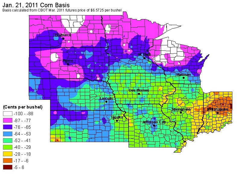
On a pilot basis CARD is posting daily basis maps for corn and soybeans. The purpose of this pilot project is to determine if farmer decisions about where to deliver corn and soybeans can be enhanced. We present maps showing both old crop basis and new crop basis. Old crop basis equals the current local cash price minus the nearby futures price on the Chicago Board of Trade. New crop basis equals the local forward price for future delivery less the new crop futures price on the Chicago Board of Trade. Local price data are obtained from DTN. We then employ a spatial smoothing algorithm to develop the maps.
Maps for different days can be obtained using the "Change Date" link below. Also, historical county-average basis patterns for corn and soybeans throughout the year are available. Click on your county in the map below or choose your county from the menu below the map. The basis is computed as the difference between the local cash price for the crop and the nearby futures price on the Chicago Board of Trade. Historical local cash price data was obtained from CashGrainBids.com.
Map date is January 21, 2011